My Historic Old Silk Route (Sikkim) Journey – Part II
Aritar – Rongli – Lingtum – Phadamchen – Zuluk
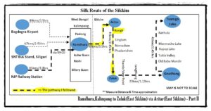
This second part of my historic old silk route journey has described the journey from Ramdhura in West Bengal to Zuluk in Sikkim. It was a very important part of the old silk route. The famous places are located at an altitude of about 5000 feet to 10,000 feet above sea level and these are rich in history and natural beauty. The overnight stay at Aritar and the next day, after collecting permits from Rongli Bazaar, the journey to Zuluk was the start of the real old Silk Route journey. Then Padamchen, via Lingtam to Zuluk, was a magnificent ride, never to be forgotten. But it is not possible to describe each place along this route in one post, so I have tried to give an idea. Each offbeat place has its own unique history, story, and natural beauty.
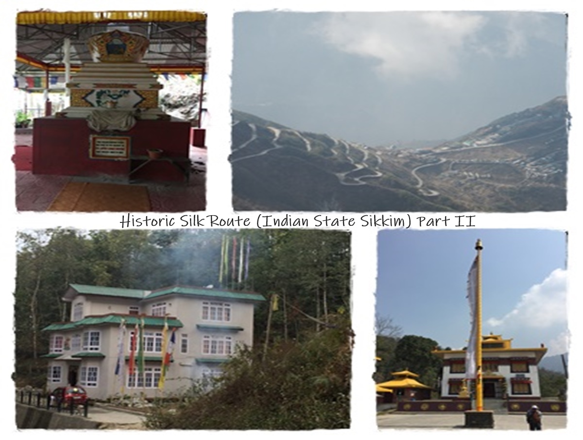
On March 8th, 2017, we woke up early in the morning to watch the Kanchenjunga sunrise from the balcony of Ramdhura homestay, but unfortunately, due to cloudy weather, we could not see it. Ramdhura’s overnight stay was good. After breakfast, we started for our next destination, Aritar. This is how we entered Sikkim from West Bengal, and our car first halted in front of the main gate of Arita Lake. Thus began the Sikkim chapter of our Silk Route itinerary. After seeing Aritar Gumpa, we started walking towards Mankhim Viewpoint. Although it was difficult to climb the stairs, seeing the natural beauty of the surroundings and the beautiful Rai temple, forgot all our troubles. Finally, we reached Sangay Homestay. After delicious lunch, the owner of the homestay offered to take me to some unknown places around the homestay, and I immediately accepted without any hesitation. Because locals are the best guides. We first went to a small gumpa located on a jungle trail. I was mesmerized by the serenity of the gumpa and the mystical atmosphere of that place. Buddhist monks choose these places to practice peace and meditation. Then, through the cardamom plantations, we reached the highest point of the hill, which is known only to the local people. From that place, one can see sunrise and sunset and a uniquely beautiful view of Aritar Lake. Mt. Kanchenjunga can be seen if luck is good. He told many unknown stories about Aritar.
Aritar – Where one of the oldest natural lakes in Sikkim is located
Altitude & State
Approximately at 5,100 ft above sea level. It’s located in the eastern part of the Indian state Sikkim. It is in the Pakyong district under Rongli Subdivision.
People, Language & Livelihood
The diversity of various tribal communities like Lepcha, Rai, Sherpa, Newar, Bhutia, etc. can be lived here. Most people use Nepali language. Most depend on agriculture and animal husbandry. Tourism is currently the main source of income for the locals. Hence, eco-tourism is playing a significant role in the region.
Nearest Medical Facility of Aritar
- Community Health Center, Rhenock
- Public Health Sub Centers at Aritar, Padamchen & Gnathang
From Aritar(approx. measurement)
| Destination | Distance(KMs) |
| Bagdogra International Airport(IXB), West Bengal via NH10 | 116 |
| Pakyong Airport(PKY) | 42 |
| NJP Railways Station, West Bengal | 109 |
| SNT Bus Terminal, Siliguri | 105 |
| Gangtok via Rangpo | 67 |
| Ramdhura | 43 |
| Rhenock Bazar | 12 |
| Rongli Bazar via Rhenock-Rongli highway | 15 |
| Zuluk | 45 |
How to Reach Aritar
You can reach Aritar directly by Reserved Car from Airport or NJP Railway Station or Siliguri. Shared Jeep service is available from Siliguri to Rangpo, then need to reach Rhenock, finally Rhenock to Aritar. You can get a Sikkim Government bus from SNT, Siliguri to Rongli.
Nearest Attractions of Aritar
- Mankhim Viewpoint: This is Hill top point and located at a height of 6500 ft at Maity village (Kheselakha). From Here, you can see 360 degree panoramic view of Mt. Kanchenjunga if weather is clear and the boot shaped Aritar lake. Mankhim Rai Temple is one of the tourist attractions; the Rai community celebrates the festival ‘Sakewa’ every year.
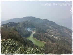
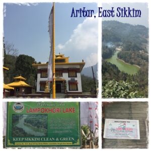
- Lampokhari(Artitar Lake): As per Indo-Nepali community, LAM means Long and POKHARI means Lake. One of the oldest natural lakes in Sikkim. Situated at an altitude of 4600 feet and it is 1120 feet long and 240 feet wide. The Boot Shaped & emerald-green colored lake surrounded by green pine forests and hills. There is a small temple dedicated to Guru Padmasambhava on the banks of the lake. You can enjoy boating also.
- Nature Walk: As part of the village walk, you can follow the hidden trail of the old silk route in Mankhim and interact with locals for more information about these offbeat places.
- Aritar Gumpa (Monastery): This is one of the holiest and oldest monasteries in Sikkim that belongs to the karma Kagyu descen of Tibetan Buddhists.
- Parbateyswar Shivalaya Mandir (Lord Shiva Temple)
- Dak Bunglow: Locally known as Ari Bangla which was built by Sir James Claude White (first political officer of Sikkim during British in India) in the year 1895. This is famous of its history as Sikkim’s first treasury was built at same premise and the Sikkim Police was raised here.
Waterfalls
- Changey Waterfalls: 50-meter height and located near Lampokhari.
- Kali Khola Falls or Quo Khola Falls (Also known as the Lonely Falls): 100 meters of height at Rorathang-Rongli Road. In Nepali, Que means Potato & Khola means Stream.Before potatoes were cultivated here, local people cleaned those potatoes under this waterfall. In this way the waterfall has been named. In the rainy season, the original form of this waterfall is seen.
 Trekking & Hiking from Aritar
In here, travelers can do short low altitude Himalayan trekking routes. Always better to hire a local guide for these treks. Homestay owner or Local Trekking organizing company can arrange low & high-altitude treks both if you want and they provide tent or trekker’s hut accommodation, guide, porter, food, transportation and Service.
- From Mankhim to Aritar Lake (Short Type): It is 1.5kms trail passes through the dense forest.
- You can do a short trek (around 4hrs) to uphill Phusrey or Phushrey Lake (Mulkharka Pokhri in Nepali) which is located about 7,400 feet height from the sea level. The majestic Mt. Kanchenjunga reflects in this pristine natural lake; hence it is known as the “Mirror of Kanchenjunga“. Local people believe that this lake fulfills people’s wishes, hence they fondly call it Manokamana Pokhri.
- Pangolakha Wildlife Sanctuary Trek (Moderate Type): This adventurous trek starts from Mankhim.
- Rachela Trek (Moderate Type): RacheLa (LA means Pass) is the highest point in the untouched and biodiversity-rich Neora Valley National Park, located at a tri-junction of West Bengal, Sikkim, and Bhutan. During the trek, red pandas, wild orchids, butterflies, and birds can be seen, making the experience unforgettable. From Rachela’s top, you can see the Chola and the Singalila ranges, with majestic views of Kanchenjunga.
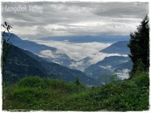
- The known adventures trekking route leading towards Lungchok valley, which is located near Lokdara, Chujachen.
Click on the below link to get more information about Lungchok Valley
Lungchok – A Picturesque Village in East Sikkim
Local Festivals of Aritar
- Lampokhari Tourism Festival (Lampokhari Paryatan Mahotsav): This is a new attraction for this offbeat tourist destination. It is a three-day long festival which has been celebrated every year during the Hindu festival ‘Ramnabami’(end of March to April) since 2007. This is organized by the ARITAR DALAPCHAND LAMPOKHARI DEVELOPMENT SOCIETY (ADLDS) in collaboration with the Sikkim Government. This festival is organized with many types of cultural events and many adventurous sports such as mountain cycling, paragliding, boating, trekking, and archery, which are great attractions for adventure lovers. One of the attractions is the local cuisine. We can easily get the taste of Lepcha, Newar, Rai, Bhutia, and other communities’ own food at the festival.
- Sakewa Festival: The Rai community, which is a worshiper of nature, organizes the festival every year in April or May on the Mankhim Rai Temple premises. The aim of this festival is to sow plants and make nature greener. During this festival, different types of colorful dance forms and musical events are performed by the local community.
Where to Stay in Aritar
Many homestays & Resorts are available in Aritar and Mankhim both, and they provide accommodation & food both. Transportation available if it is required. Nowadays most of the homestays has own website & online booking system, you can easily get all information. Below are details of some homestays.
- Sangay Homestay
Gumpa Dara, on the way to Mankhim
+91 97330195461,9563105530
We stayed at this homestay. From our rooms we could see the villages of Lava, Lolegaon & Rishop which are located in west Bengal from the room windows.
- Karma Homestay
Aritar, Dalapchand, +91 9933409513,9800754559
Website:www.karmahomestay.com
- Shraddha Homestay
Aritar, Dalapchand,+91 9609788505
- Kanchanjunga Mirror Homestay
Mankhim(Maity Village), Aritar
Contact: Mr. Lalit Rai, +91 9775915047,7047950248
- Lamphokori Homestay
Close to Aritar Lake, Aritar,+91 9734004744,8167897152
Best time to visit Aritar:
Summer is best time to travel. Very pleasant & clear weather. In Monsoon time, heavy rainfall happens so the possibility of landslide is very high and outdoor activities will be affected. In Winter, Harsh chilly weather. That time Temperature drops to close freezing point and heavy snowfall chances. Some adventurous travelers enjoy this snowfall session.
On March 9th, 2017: After breakfast at SANGAY HOMESTAY, Aritar, we waited for the new driver, as the next ride would be in the said Tata Sumo vehicle, which is very suitable for high-altitude travel. We started our journey to the next destination, Zuluk, but before that, we took our permit from the SDPO office, Rongli. Our driver did all the activities, and it took about an hour, but it depends on the crowd. I have already mentioned all the details about getting permits in my previous post.
Before completing the permit work, we did some necessary shopping from Rongli Bazar, as we would not be able to find a market like this again in the rest of the route. When our driver returned, we started our journey to Zuluk, which is the real starting point of the Silk Route journey.
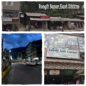
Rangli or Rongli Bazar
It is an important transit point in Sikkim and a small village in East Sikkim. From here you can go to many offbeat places in East Sikkim, so this place is very popular with tourists. The Rangpo river flows through this village. Many shops, restaurants, hotels, homestays, resorts, and government offices can be found here. There are also schools, primary health care, and private medical centers. From the SDPO office in Rongli, you need to get an Inner Line Permit to travel on SilK Route.
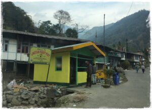
Passing Rongli Bazar, we saw Que Khola Falls, which is about 100 feet high and located on the road to Nimachen. Then our car reached Lingtum, which is the first check post on the Silk Route and It is about 9 km away from Rongli bazar. Our permits were checked at this check post.
Lingtam or Lingtum
This is a small quiet hamlet in far eastern Sikkim with a beautiful green valley, a flowing hilly river, birds chirping, and beautiful monasteries. It is situated at an altitude of around 5082 ft above sea level. From here, you can trek to Pangolakha Wildlife Sanctuary, which is quite an adventurous and thrilling journey. It is good to book in advance because there are not too many homestays and resorts. We didn’t stay here because it wasn’t on our itinerary. After verifying our permit, we were allowed to enter the old Silk Route.
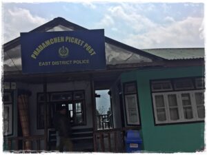
Padamchen or Phadamchen
It is the second checkpoint on the Silk Route and is a quiet resting place before climbing the high-altitude points. The place is situated at an altitude of around 7000 feet and is surrounded by a dense green forest, which is home to colourful butterflies and many species of birds. Hence, this small Himalayan village is a paradise for bird and butterfly watchers. The weather here is pleasant throughout the year. Even in winter, this offbeat destination is not as chilly as other higher regions of the Silk Route. You can visit anytime and enjoy the wonderful beauty of nature. There are some homestays to stay at here. However, we were not able to stay here as per the itinerary this time. But we will stay here for a few days in the future. We started our journey to Zuluk with this mindset.
Note: The Forest Department of Sikkim Government takes a entrance fees to Wildlife Sanctuary.
For those who want to experience the scenic beauty and historical significance of the offbeat places along the old Silk Route (Sikkim) and its surroundings, I would recommend contacting Mr. Roshan Rai of Nirvana Tours & Travels. He is a young entrepreneur with philosophical thoughts, a versatile singer, a nature lover, and the owner of this travel agency.
Nirvana Tours & Travels
Contact: Mr. Roshan Rai, Rolep-Sikkim
Phone: +91 8167885435 (WhatsApp)
![]() You can see some selected stunning photos & videos by clicking on the blog’s Instagram, Facebook and X(Twitter). Also, click the Gallery Section of this blog for only photos. I hope you will like those.
You can see some selected stunning photos & videos by clicking on the blog’s Instagram, Facebook and X(Twitter). Also, click the Gallery Section of this blog for only photos. I hope you will like those.
For other the Old Silk Route posts, click below links.
My Historic Old Silk Route (Sikkim) Journey – Part I
My Historic Old Silk Route (Sikkim) Journey – Part III
Zuluk or Dzuluk – A meeting point with Clouds
Altitude & State: Approximately at 10,000 feet above the sea level. It’s located in the eastern part of the Indian state Sikkim. It is in the Pakyong district under Rongli Subdivision.
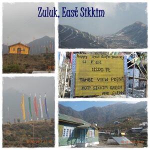
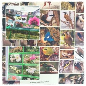
Finally, we reached Zuluk or Dzuluk. A small mountain village, which is situated at a height of 10,000 feet from the plane and the intimate association between snow and green. This village was one of the important transit points of the Old historic Silk Route that connects to Chumbi Valley in Tibet through Jelep La. This quaint eastern Himalayan hamlet is one attractive offbeat tourist spot, so many offbeat tourists now spend the night here but the place to stay here is rather less than the tourist. There are homestays here but it’s better to book in advance. This village is very close to Tibet & Bhutan border, so Zuluk has an army establishment and a Helipad that is located at the top of Zuluk. The condition of the roads is good enough and well maintained by BRO (Border Roads Organisation). The dense forest consists of wild animals like Himalayan bears, wild dogs, red panda and others and some parts of the forest is still untouched by human.
The homestay owner of Mukhia Homestay was waiting for us because we were late. The hot tea came in as soon as we entered the room because the outside was very cold. Here day and night temperature vary drastically. The mesmerizing views of the mountainous village were very beautiful from the homestay’s balcony. At lunch we were given various types of Nepalese dishes and the food quality was tasty & good. We started village tour after lunch. We saw a Shiva temple, various types of vegetables growing in a greenhouse made of polythene sheets, some small shops, roaming mountain dogs, and many unknown birds in here.
From Zuluk(approx. measurement)
| Destination | Distance(KMs) |
| Bagdogra International Airport(IXB), West Bengal via NH10 | 139 |
| Pakyong Airport(PKY) | 68 |
| NJP Railways Station, West Bengal | 134 |
| SNT Bus Terminal, Siliguri | 129 |
| Gangtok, Sikkim via Tsongo Lake | 90 |
| Rangpo via Rangpo-RorathangRoad | 54 |
| Gnathang Valley | 23 |
People, Language & Livelihood
The inhabitants here were mainly from Nepal and Tibet. Earlier, they were associated with road construction & maintenance, while some worked as coolies in the army. Due to the infertile soil and adverse weather conditions here, agriculture is very difficult, but currently, various types of vegetables are grown in polythene greenhouses. Grazing is not possible here as most of the areas are under army control. Therefore, nowadays, people here are highly dependent on tourism. Locals are friendly, honest, simple, and hard-working.
How to Reach Zuluk
You can reach Zuluk directly by Reserved Car from Bagdogra Airport or NJP Railway Station or Siliguri. Shared Jeep service is available from Siliguri to Rangpo which is one the entry points of Sikkim. From Rangpo you can reach to Zuluk through Rorathang.
The best way to reach to Zuluk from Ramdhura, Aritar, Reshi route.
You can also reach Zuluk from Gangtok via Tsongo (Changu) Lake, but a permit is relatively difficult to get compared to another route Rongli.
Nearest Attractions of Zuluk
- Nature Walk: In this valley, you can follow the actual old silk route trail, which will give you a nostalgic feeling, and you can basically enjoy the raw nature. This is an ideal place for nature photography. Bears roam here after dusk, so be careful.
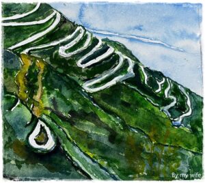
- Thambi Viewpoint: This popular point is located at a height of 11120 feet above the sea level and around 14 kilometers away from Zuluk. You can see a clear view of 32 sharp hairpin bends in a single road which is famously known as Zigzag Road on one side, and you can get a chance to have a look to a panoramic view of the entire Mt. Kanchenjunga range if weather is clear on other side. The zigzag road is not part of actual old silk route, and this road was built much later to facilitate transportation. You can enjoy tea or coffee in this charming natural environment from the fast-food stall of this point.
- Nag Temple: Along the way which is on the actual old silk route.
Note: Will be mentioned rest of attractions in my Last part of the Old Silk Route journey.
Where to Stay in Zuluk
Local people run homestays. This is their main earnings now. They provide accommodation & home food both at reasonable price and amenity of these homestays are modern & clean and room heater available if it is required. Transportation is available if it is required. The number of homestays is less here, so it is better to book in advance. Below are some homestays.
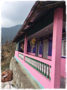
- Mukhia Homestay
Contact: S.B. & Sushma Mukhia
+91 9593778166,9735263725 - Zuluk Sojourn Homestay
+91 9903295920 - Snow Lion Zuluk
+91 9475655077(WhatsApp),8902280864 - Thupten Kalsang Homestay,Zuluk
+91 8597954150(WhatsApp),8900286717
Best time to visit Zuluk
From September to October, this place is covered with different vibrant color wildflowers, the whole place becomes a paradise. In Rainy Season, outdoor activities will be affected due to foggy and cloudy weather. But there is very good weather in the rest of the year. In Winter, some adventurous travelers enjoy this snowfall session. The road is often blocked due to heavy snow during this period.

Currently, many new places have been added to the old Silk Route that are not far from Rongli. From there, we can also travel on the Silk Route. These places are really offbeat and hidden. Rolep, Chachal, Lungchok, Lossing, Doban Valley, and other new offbeat places will be highlighted in my blog in the coming days.
Please wait for the last part of the Silk Route, where the places are located at an altitude of 10,000 feet to 14,000 feet, which will be full of exciting & unknown facts.

I have only shared with you my memorable experiences with homestay owners, drivers, or tour guides while traveling, but your experience may not be the same as mine. Hence, I have no responsibility in that case. I am just sharing information only.

- Neora Valley National Park is also known as the land of the elegant Red Panda.
- Rhenock (Black Hill) is a small village in East Sikkim which was the first resting place in Sikkim along the Lhasa-Kalimpong trade route earlier. In the Lepcha language, RHE means Black and NOCK means Hill.
Comments
Leave a Reply

Beautiful pictures and informative writing.........for travel......
Piyali, thank you very much for encouragement.
Nicely and carefully written..Detailing r good and well categorized. love to do expedition very soon...Thank u friend sharing this magnificent experience to us..
Thanks Bandhu for your inspirational feedback.
Well described. You have covered all this area elaborately. Waiting for your next blog.
Thanks Bandhu for your inspirational feedback.
You describe the place thoroughly and the people's religion, culture, festivals etc.one can visit the place following your description without trouble.
Thank You!!! We will travel together again.
Beautifully written. The way you have shared your experience gave the feeling of being right there on the silk route journey. Kudos and thank you for sharing your experience.
Hello Bhai, Thank you very much!!! Definitely, your inspirational comments will encourage me to write more interesting posts.
Wonderful!!! Covered every detail required… very Good job Dost!! Keep it up
Samar bhai, thanks for your inspiration.
Very good details about travel and places to visit.
Thanks Manish.
Very nice Blog Keep it up
Bhai, Thank you very much!!!