My Historic Old Silk Route (Sikkim) Journey – Part III
Lungthung & Gnathang Valley
I have narrated the story of my journey from NJP to Zuluk in my previous two posts which are on the Old Silk Route, Sikkim. The greatness and importance of each place in this part of my journey on the old silk route is immense, I have tried to convey as much of it to you as much as possible.
The previous night’s bone-chilling cold made us realize the difference between daytime and nighttime temperatures in Zulu. As usual, we loaded all our luggage into the car, as our next overnight stay was at Gnathang Valley. After breakfast, we said goodbye to our homestay owner and started our next journey, which was the most adventurous part of the Silk Route.
In this last part of my historic Old Silk Route (Sikkim) journey, I have mentioned the most exciting and historical places along this route, which are located between 10000 feet and 14000 feet.
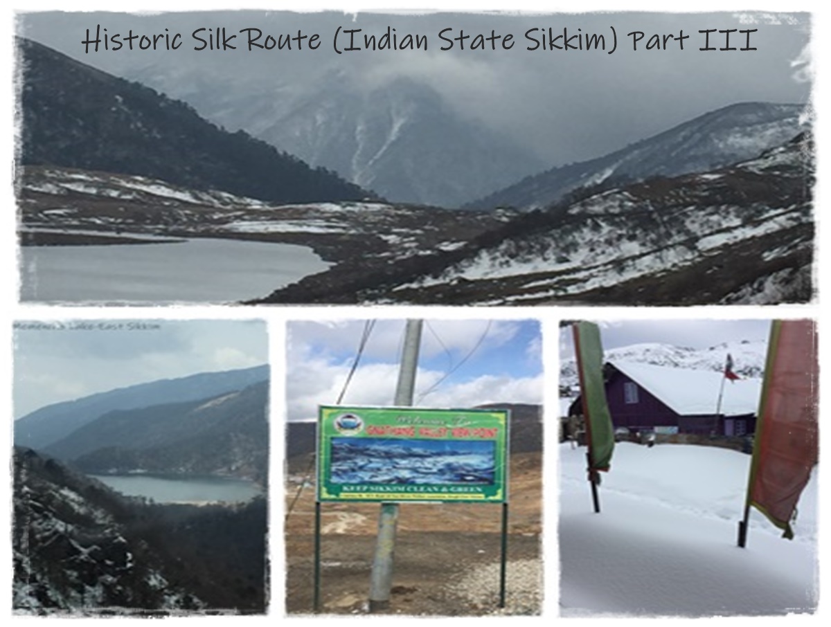
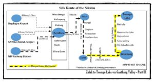
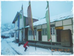
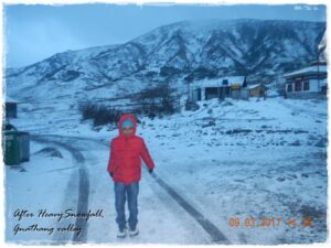
As per our itinerary, we visited Lungthung, Laxman Chowk, Gnathang Viewpoint, Tukla Valley, Old Baba Temple, Jeelep-La, Kupup, Serathang, and Tsomgo(Changu) Lake, then came back to Nathang Valley for an overnight stay. Here, we stayed at a homestay named Golden Trout Residency. We were supposed to stay only one night but had to stay one more day due to heavy snowfall. As a result, we were forced to change our next plan. Due to not being able to cancel the ticket from Gnathang, we did not get a full refund for the return bus from Siliguri to Kolkata and faced difficulties at our booked hotel in Rongli. It is true that we faced financial losses due to sudden change in our plans, but the mesmerizing snowfall in Gnathang Valley made us forget all financial losses and hardships.
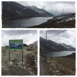
Lungthung (Also known as Dhupidhara)
This calm village is located at a height of 11,500 feet above sea level, a spectacular offbeat tourist spot in the eastern Himalayas. It is located close to Thambi Viewpoint (4 km away). On one side of which is the picturesque view of Kanchenjunga, and on the other side is the zig-zag road (Bhulbulaiya) of Zuluk. Travelers can view a spectacular sunrise over the peaks of the Kanchenjunga from Sunrise Point in Lungthung. As per locals they have sighted Yeti or Banjhakri(in Nepali), travel can hear stories from locals here on this. The offbeat place falls under the Pangolakha Wildlife Sanctuary, which is home to different types of flora and fauna. Bird watchers can see different species of birds such as the Blood Pheasant (the state bird of Sikkim), the Himalayan Monal, the Laughing Thrush, the Rose Finch, the Fire Tailed Sunbird, etc. This place is the natural habitat of the Red Panda, which is the state animal of Sikkim. There are some homestays to stay at here. Mainly, Tibetan refugees live in this village.
Laxman Chowk
Most of the people called this chowk as Luxmi Chowk. The Laxman Chowk was built in the fond memory of Lt. Col. Laxman Singh, which is located at 12800 feet. You would get a panoramic view of Kalimpong, Pedong, lava, and Algarah along with the Himalayan range from Laxman Chowk and a cafeteria built by the Sikkim Tourism Department.
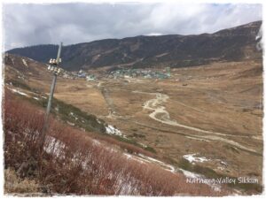
Gnathang or Nathang Valley – Ladakh of the East India
This small hill village is situated at a height of 13,500 feet above sea level and surrounded by snow-clad mountains. Basically, this is a village of migrated Tibetans. Nowadays, this offbeat area is one of Sikkim’s most popular tourist attractions. A stream has crossed Nathan Valley, and there is a small bridge over the stream. The valley is also an ideal place for yak herders due to its vast pastures. Earlier locals were associated with road construction and maintenance.
Essential Information of Gnathang or Nathang Valley
Altitude & Location: Approximately at 13,500 feet above the sea level. It’s located in eastern part of Indian state Sikkim. It is in the east district under Gangtok Subdivision.
From Gnathang (approx. measurement)
| Destination | Distance (KMs) |
| Bagdogra International Airport (IXB), West Bengal via NH10 | 163 |
| Pakyong Airport (PKY) | 91 |
| NJP Railways Station, West Bengal | 157 |
| SNT, Siliguri | 154 |
| Gangtok via Tsomgo Lake | 66 |
| Tsomgo Lake | 29 |
| Kupup Lake | 9 |
| Memencho Lake | 11 |
| Old Harbhajan Babaji Mandir | 5 |
| Lungthung | 6 |
| Rongli Bazar | 53 |
How to Reach
You can reach Gnathang directly by Reserved Car from Bagdogra Airport or NJP Railway Station or Siliguri via Zuluk and this is the best way. You can also reach Gnathang from Gangtok via Tsomg Lake, but a permit is relatively difficult to get compared to another route Rongli.
Nearest Attractions
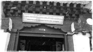
- Gnathang Gadenchoeling Gumpa: This is one of popular point in this valley. It’s very close to Golden Trout Homestay.
- Local Hindu Temple
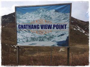
- Gnathang Viewpoint: From where you can see the Nathan valley.
- Eagle’s Nest Point: If you are nostalgic, do not miss the eagle’s nest point, which is located 13700 feet high, located a few kilometers away in the Nathang Valley. This is a deserted mountain army bunker, from where you can get a full 360-degree panoramic view of East Himalayas. This is also considered as a popular sunrise point. From here you will see Kanchenjunga range which your unforgettable experience will be.
- Gnathang (Nathang) village has a British soldiers’ cemetery with a war memorial.
- Tukla Valley: This valley is located about 15 km from Kupup, which is close to the international border. Only some parts of Tukla Valley are accessible to civilians. This valley has a Famous eighteen-hole golf course named Yak Golf Course. A war memorial is in the Tukla Valley, which was built for commemorate the deaths of British soldiers in Anglo-Tibetan War of 1888. The old Baba Mandir is also located here.
- Yak Golf Course & Environmental Park:18 holes and 6026 yards long golf course is situated at 13,025 feet above the sea level in Tukla valley and affiliated to Indian Golf Union. The course first was started in 1972 and has been redesigned several times over the decades and finally expanded into a full 18-holes golf course. On 10thOctober 2006, the Guinness Book of World Records recognized this golf course as the highest altitude golf course in the world. During the winter, the golf course became the main attraction of various winter sports such as ice hockey, ice skating and skiing.
- Younghusband’s Track: It is located in Kupup, which is a small valley. The distance from Kupup Valley to Lhasa is only 520 km and you get a famous signboard by specifying the distance with directions. From the year 1903 to 1904, Lt. The British army led by Colonel Francis Younghusband used this track to conquer Tibet, and this was the first expedition to conquer Tibet by any European army. The British army started the military operation from Siliguri, went to Rongpo & Nathang. After that, reached Chumbi valley through the famous Jelepla pass and finally reached Lhasa to conquer Tibet.
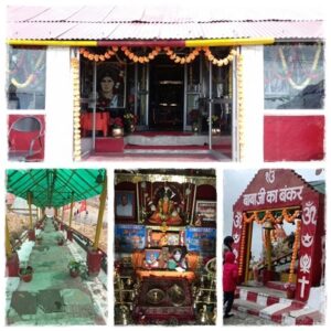
- Old Baba Mandir (Bunker of Baba Harbhajan Singh): Before visiting this temple, you must know a little about its history and why an Indian soldier is still worshiped as a god. Therefore, I have tried to give a brief outline of its history.
Back to History of the Old Baba Mandir
Harbhajan Singh was a sentry, belonging to the Punjab Regiment of the Indian Army and deployed in the security forces near the international border in Sikkim. Suddenly, he disappeared in October 1968. It is believed that while he was carrying a mule carrying food, Harbhajan Singh suddenly slipped and fell into a fast-flowing mountain stream and unfortunately drowned. Despite all efforts to locate him, his body disappeared. A few days later, he reappears in the dream of one of his army colleagues (Pritam Singh) and informs him of his tragic death. He also reported that her body was lying under a pile of snow and requested that a memorial be built in her name. But Pritam Singh did not give much importance to his dream. But later, everyone is shocked when Harbhajan Singh’s dead body is found at the place mentioned in the dream. Soldiers built a samadhi at a height of about 13,123 feet as per his wishes and later a temple was built, popularly known today as “Old Baba Mandir“.
It is believed that his spirit still lives and guards the border in this remote area. A friendly spirit alerts the patrolling jawans if anything suspicious happens. Even today, his suitcase is respectfully packed every year and sent on vacation to his hometown Punjab. He was brought back to serve again. Inside the temple, you will find a large statue of Harbhajan Singh. On one side of the temple is Harbhajan Singh’s office, where he is believed to conduct his daily work. Beside his eating place. One room contains his bed, shoes and uniform. Army jawans offer mixed dry fruits as prasad to the visitors every day. Harbhajan Singh may have died long ago, but based on several eyewitness accounts, his supernatural actions convinced the Indian Army of his patriotic heroism. In recognition of his love for the country, he was promoted to the rank of captain. Memories will last forever…
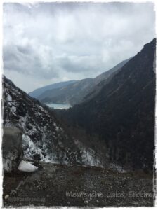
- Menmecho Lake or Memencho Lake: This natural lake is located on the path to the Jelepla Pass and at a height of 12,500 feet above sea level. This is one of the most beautiful lakes in Sikkim and the source of the Rangpo Chu (Chu means river in Bhutia), which is a tributary of the Teesta River. This high-altitude lake is surrounded by green pine forests and mountains. Every year, many tourists and trekkers travel here to explore the colors of the lake. Cars cannot reach Memencho Lake directly. Hence, travelers can make a short trek to reach the lake. In addition, this lake is famous for its trout fish, and this is one of the best trout cultivation centers in Sikkim, maintained by the Fisheries Department. There is a beautiful bungalow on the lake’s banks. If you stay in this bungalow, you will have an unforgettable experience. However, special permission is required in that case, as the road leading to this lake is guarded by the Indian Army.
- Kupup Elephant Lake or Hatipokhari Lake: The lake is considered one of the sacred lakes of Sikkim. This dark blue lake is located 14000 feet above sea level on the path of the Jelepla Pass, near the India-Tibet border. Kupup Lake is also known as “Bidan Cho” or “Hatipokhari” to the locals because of its resemblance to an elephant. Kupup Lake is covered with ice from January to mid-May.
- Tsomgo Lake or Changhu Lake: This is one of the most popular tourist attractions of Sikkim and a habitat place to numerous species of birds. This magnificent oval-shaped glacier lake is situated at a height of 12,700 feet above sea level. Located on the Gangtok-Nathula highway, about 40 kilometers away from Gangtok.
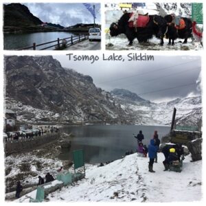
In local language Tsomgo means Source of Water. In each season, this lake has unique natural beauty. Sikkimese believes that this lake is sacred and associated with many myths. In ancient times, Buddhist monks studied the color of the lake water for predicting future. Also, local people believed that lake water has medicinal qualities. Every year Guru Poornima festival is celebrated near this lake. You can enjoy a ride on colorfully decorated yak or mule around the lake. This is really a great experience. Snow boot and protective clothing are available in winter if you need them. There are numerous fast-food stalls available here. There are also other types of shops where you can get souvenir gift items.
Department of Tourism & Civil Aviation Department, Government of Sikkim has started Tsomgo Passenger ropeway (Cable Car) at a height of 14,500 feet near this lake.
This lake is accessible to both Indian and foreign tourists. Foreigners need to apply for permit through a government-registered travel agency.
Trekking & Hiking
Adventures can make many short tracking routes from here. Always better to hire a local guide for these treks. Homestay owner or Local Trekking Company can help.
Two Great Mountain Passes on the Old Silk Route (Sikkim, India)
Jelepla: It is a high-altitude mountain pass at 13,999 feet links Lhasa to India. As per the Tibetan, the word “Jelep La” means “The Lovely Level Mountain Pass”. Because this is all- weather pass, and it doesn’t get blocked with snow unlike NalthuLa. In the year 1871, the trade route started through this pass and after that it flourished more after Colonel Francis Younghusband’s travel to Tibet in 1904. Most of the warehouses on the Indian site were setup at a place called 10th Mile in Kalimpong. So, Jelepla starts from Kalimpong and through Algarah & Pedong and passes through Rhenock, Aritar, Zuluk and Kupup in Sikkim. After that, the pass connects the Chumbi Valley in Tibet plateau. This ancient trade route boosted the economy of Kalimpong region till the pass was closed after Chinese aggression in 1962. If the route was reopened, the economy of Kalimpong and other important points on the route would probably be restored. The route is scenic with forests of rhododendrons blooming in spring.
Nathula or Natula: Nathula Pass is a famous mountain pass in the Eastern Himalayas. Located on the old silk route at the Indo-China border and this is gateway between India and China. The Indo-Chinese border is situated at an elevation of 14,140 feet and acts as a trade link between two countries. Also, this is one of the highest altitudes motorable roads in the world. In the Tibetan language, Nathu means “Listening Ears” and La means “Mountain Pass“. This pass is open for Indian nationals only on specific days, but foreigners are not allowed to this place. Tourists are allowed to go to the international border from where they can see Chinese Army office and their bunkers. You can get the benefits of ATM here, which is the highest altitude ATM facility in the world. If weather is nice then you can see the captivating view of Chumbi valley of Tibet, guarded by snow covered mountains.
Note: Photography is strictly prohibited.
Where to Stay
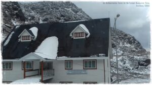
There are no hotels in this offbeat destination. Farming is very low here, so local people run homestays. This is now their primary source of income. They offer affordable lodging and home-cooked food. The amenities at these homestays are modern and clean. Transportation is available if you want to see the nearest attractions. The locals are very hospitable and generous. Snowfall occurs frequently during the winter, so gumboots are essential. Homestay also provides gumboots if you require them. The number of homestays is lower here, so it is better to book in advance. You can book these homestays through different online booking sites as well.
- Golden Trout Residency +91 8900084103,9830027451,9830565100
The location of this hotel is in the best location of Gnathang Valley, from which the best view of the valley can be seen and is very close to the old monastery. The lady who owns the hotel was very kind as we had to stay longer at her hotel due to heavy snowfall; she took great care of us and even arranged our return trip to Rongli, which we will never forget. The food served was homey and delicious.
- Dolma Homestay
- Gnathang Residency +91 94348 54141
- Dikki Homestay +91 8420415819
- Sonam Homestay
- Sunset Homestay +91 7501404544, 9476298184

I have only shared with you my memorable experiences with homestay owners, drivers, or tour guides while traveling, but your experience may not be the same as mine. Hence, I have no responsibility in that case. I am just sharing information only.
Best Time to Visit
Each season has its own beauty, and Gnathang Valley changes its appearance according to the seasons. Therefore, enjoying that beauty will depend on the travelers. In the springtime, this place is covered with different vibrantly colored wildflowers; the whole place becomes a paradise. Due to the drying of the grass in the autumn, the valley seems to be golden. Travelers can see a spectacular view of the golden-hued grasslands.
In the rainy season, landslides are frequent, and the roads are blocked at any time, but the BRO and the Indian Army clear the road in a short period of time. Some adventurous travelers enjoy this season.
In the winter, the climate is very cold and snowy. The valley is covered by thick snow, and snowfall is very regular.
Before coming here, it is good to come up with thick, warm clothes. Senior citizens and children may suffer from high altitude sickness. If someone suffers from breathing problems, they should avoid staying at Gnathang and stay at the nearest low-altitude places like Zuluk or Padamchen.
 We got stuck due to heavy snowfall and several feet of snow covered the entire valley. As a result, all the roads were closed. But the villagers cleared the snow and cleared the road otherwise all the tourists would have had to stay for a few days. We will never forget their help. So, thanks to all the villagers of Gnathang through my blog.
I still have the desire to travel to other offbeat places of the old silk route and hope to do so in the future. But when I think about one thing, I am very surprised at how difficult it was to make that long journey from one country to another through unfenced borders, sometimes on horseback or sometimes on foot. That effort was actually the first stage of modern world trade.
This blogpost is my last part of my historic Old Silk Route (Sikkim) Journey. Below are links of earlier blogposts on the historic Old Silk Route (Sikkim).
My Historic Old Silk Route(Sikkim) Journey – Part I
My Historic Old Silk Route(Sikkim) Journey – Part II
![]() You can see some selected stunning photos & videos by clicking on the blog’s Instagram, Facebook and X(Twitter). Also, click the Gallery Section of this blog for only photos. I hope you will like those.
You can see some selected stunning photos & videos by clicking on the blog’s Instagram, Facebook and X(Twitter). Also, click the Gallery Section of this blog for only photos. I hope you will like those.

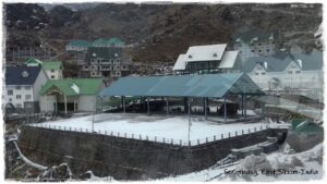
- Serathang Trade Mart (Indo-China Border Trade): A long shed with shops of Indian and Chinese traders. This trade mart was opened on 6th July 2006 as per the bilateral trade agreement between India and China.
- The Ministry of External Affairs (MEA) of India operates the Kailash Mansarovar Yatra route through Nathula (Sikkim, India). At Serathang (Sikkim), pilgrims stay here for acclimatization. The route is completely motorable, making the entire journey easier than other routes.
Comments
Leave a Reply

A vivid description of the places,valuable informations and sugesstions regading the trip are indeed very useful to the first time travellers.
Thank you very much. I will always look forward to your inspirational comments as such comments will motivate me to write better.
Informative article for new travels..... with route map.. Which is very helpful.. Thank you
Thank you very much, Piyali.
Going through your blog one can make a plan to visit the place without hesitation.
Thank you very much!!!
Good morning Sir. Thanks for sharing Such a appreciate and useful information about route n places with us.. thank u so much..Always stay healthy n wealth life..
Good Morning, Dupuji!!! Thank you very much for continuous inspiration.
Another set of great articles, Mrinal. Lot of details here. One can fully plan a visit based on your articles.
Rupesh, thanks a lot. I always look forward to your good comments as it inspires me to write better.
Wow. What a beautiful journey!!! I felt the coldness of snow and hardship while reading the blog. Such a nice description.. keep doing these my pal
Shabharish,thank you very much!!! Feeling glad to see your inspirational comments.
Great to see detailed about route and great knowledge about subject.
Thanks Manish...always boosting me.